WHY CHOOSE US

iFEWS provides an integrated suite of software products for building a complete web based flood forecasting and early warning system. The easy to use interface allows non-GIS experts to be in a position to interactively view and explore, as well as query the database, to select different data variables and to view maps at several levels of detail. This framework enables you to deploy GIS functionality and business logic wherever it is needed - desktops, servers, custom applications, web services, or mobile devices.

Real Time Decision

RTDSS Development

RTDSS Development

GIS Application Development

GIS Application Development

Climate Change DSS Development

Climate Change DSS Development

MIS Development

iFEWS Capabilities

iFEWS has number of features which make it very powerful framework for flood forecasting.

iFEWS Applications

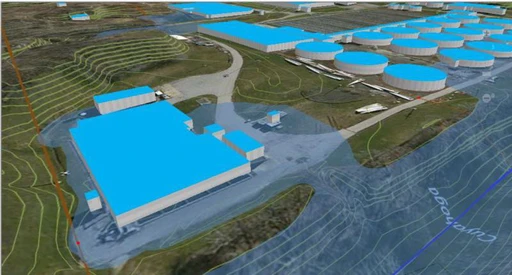
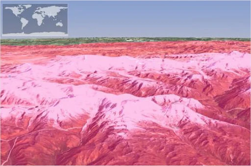
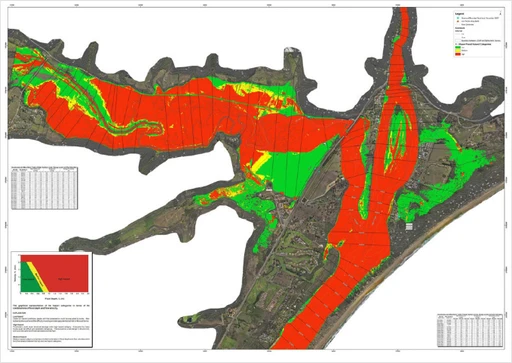
Explore iFEWS applications in India: revolutionizing flood forecasting and early warning systems nationwide.

  • Automated data downloads
  • Integration of HEC-HMS and HEC-RAS
  • Data Assimilation
  • Integrated Document Management System
  • GIS-based interactive map
  • Flood Dissemination
  • Managed interface to monitor automation
KOSI FEWS (Flood Forecast Modelling, Inundation Mapping and Early Warning System) – FMIC, Bihar

  • Automated data downloads
  • Integration of MIKE 11, HEC-HMS and HEC-RAS
  • GIS-based interactive map
  • Flood Dissemination
  • Managed interface to monitor automation
  • RTDSS Integration
DVC FEWS (Damodar River Flood Forecast & Early Warning and Inundation Modeling Project) –  Damodar Valley Corporation

  • Automated data downloads
  • Integration of HEC-HMS and HEC-RAS
  • Basin Averaging tools
  • GIS-based interactive map
  • Machine Learning
  • Scenario Management
  • Managed interface to monitor automation
  • RTDSS Integration
  • Flood Dissemination
  • Integrated mobile app and web portal
Ganga FEWS (Early Flood Warning System Including Inundation Forecast in Ganga Basin) – CWC

  • Automated data downloads
  • Integration of HEC-HMS and WEAP
  • GIS based interactive map
  • Managed interface to monitor automation
Mahananda FEWS (Basin Planning for Mahananda River) – FMIC Bihar

  • Integration of DHI MIKE HYDRO BASIN for Basin Planning
  • Integration of HEC-HMS and NAM
  • Integration of HEC-RAS for flood inundation analysis
  • Integration of WEB.BM for Reservoir Optimization
  • Integration of QUAL2K for Water Quality
  • Integration of MODELMUSE for Groundwater Modelling
  • Automated scenario-based reports
  • Cost Management Analysis and Multi-Criteria Analysis
DSS(PM) (Decision Support System (Planning & Management) – NIH, Roorkee

  • MIKE HYDRO BASIN Integration
  • Scenario Management for multi-purpose dams planning
  • Automated satellite data downloads
  • NAM based Rainfall-runoff

  • Automated proposed assets based on GIS data
  • Drought Module
  • Automated data downloads and processing
  • Asset planning management
  • Integrated mobile app
  • Automated plan reports

  • Web-based interactive GIS App to visualize data
  • Integration of sector-based data
  • Customized reports to analyze energy potentials from various waste
Waste to Energy Potential (UNIDO)

  • Web based GIS app
  • Various GIS tools
  • Integrated Document Management System
GIS Based Asset Management System (Assam Gas Corporation Limited)

  • Automation of data downloads
  • Parsing data from web crawler
  • Integrated Document Management System
  • Management of River Protection works
  • Display GIS maps
  • Development of an Integrated Mobile App
  • Export reports in various formats
URMIS (Uttarakhand River Morphology Information System)

Stay in the loop!

We look forward to hearing from you and assisting you with your flood forecasting and early warning system needs.